In medieval times, Paris was a walled city, but did you know that it remained essentially so until the 1920s? Did you realise that the impact of the walls is still felt in the Paris we know today?
In The Invention of Paris: A History in Footsteps, one of my favourite books, Eric Hazan describes the city’s growth as concentric layers, like an onion. For me this is the perfect metaphor to understand how the city has grown.[^1]
Over the centuries the walls of the city did more than defend it. They set limits, shaped streets and determined which settlements lay inside the city and which remained beyond it. Each time Paris outgrew an enclosure, another was built farther out. An old boundary might be demolished or absorbed, but its outline often survived in a road, a name or the shape of a neighbourhood. The story of Paris’s growth is written in the lines its walls left behind.
Map, dated 1937, showing the Philippe Auguste, Charles V, Louis XIII (“Yellow Ditches”), Farmers-General and Thiers walls (”les fortifs”)
By Clément-Serveau (Henri Clément Serveau, dit) (Paris, 29–06–1886 - Paris, 08–07–1972), engraver - This image is available from the Collections of the Paris Musées under the the digital ID:, CC0, https://commons.wikimedia.org/w/index.php?curid=110038716
(Click to enlarge)
Before Rome: the Parisii wall
In September 2026, archaeologists announced a discovery beneath the Hôtel-Dieu that could change what we know about Paris’s beginnings: a twenty-metre stretch of stone-and-wood wall, built in a style characteristic of Gallic fortifications. It may be part of the fortified settlement of the Parisii—the people whose name Paris still bears. Until now, there had been little archaeological evidence for a substantial Gallic settlement on the Île de la Cité, and the location of Lutèce described by Caesar remained disputed.
The initial radiocarbon results date the wall’s wooden elements to between 200 and 10 BC.[^2] The masonry also bears traces of intense burning. Caesar wrote that the Parisii set fire to their settlement in 52 BC, before the Roman forces arrived. The possibility that this is the wall he described is tantalising—but it remains a hypothesis. Further excavation and analysis are needed to establish the wall’s date and function, and whether its burning really matches Caesar’s account.[^3]
Roman Lutetia: the island wall
Once settled by the Romans, Lutetia’s main urban centre lay on the Left Bank rather than on the island. Its forum and public monuments spread across the higher slopes of the Montagne Sainte-Geneviève, away from the damp, flood-prone ground beside the river. The Île de la Cité and the Right Bank were also part of the settlement, though they were less built up.
From the mid-third century to the late fourth, under threat of invasion, the Left Bank gradually contracted. Some neighbourhoods were partly abandoned, and public buildings were stripped for their stone. In the fourth century, a fortified centre was established on the Île de la Cité. This was a shift in the city’s focus, though not a complete retreat: people did continue to live in parts of the Left Bank. The fortified area on the island covered less than ten hectares.[^4] Its wall incorporated large blocks taken from monuments on the Left Bank, particularly the Arènes de Lutèce, which had itself been abandoned.
The island’s inhabited area was much smaller than the Île de la Cité we know today. Beneath the parvis of Notre-Dame, the Archaeological Crypt displays remains of the Roman river port and the late Roman wall which are situated nowhere near our shorefront.
Here you can see the discovery of the Roman wall on the eastern tip of the island, at the back of Notre Dame.
Paris Musées / Musée Carnavalet – Histoire de Paris, Découverte du mur d’enceinte gallo-romain, île de la Cité, anonymous photographer, 19th–20th century, CC0.
(Click to enlarge)
A marker on the pavement shown here, on Rue de la Colombe, on the north side of the island, indicates another section of the wall’s route, which is now also at a significant distance from the riverbank.
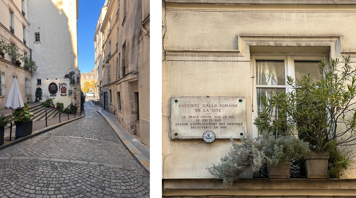
The position of the Gallo-Roman wall on Rue de la Colombe, Ile de la Cité, 4ème, and the plaque on the wall commemorating it.
© Alannah Moore, Paris Footprints 2026
Here you can see the discovery of this wall under the street in 1898. [^5]
By Godefroy, Henri Emile Cimarosa (Paris, 07–08–1837 - 19–09–1913), photographe - https://www.parismuseescollections.paris.fr/fr/musee-carnavalet/oeuvres/decouverte-du-mur-d-enceinte-gallo-romain-de-la-cite-rue-de-la-colombe-4eme#infos-principales, CC0, https://commons.wikimedia.org/w/index.php?curid=131949978
(Click to enlarge)
The early medieval enclosure(s)
There were also early medieval defences on the Right Bank, built around the end of the tenth century—approximately 978–998. Excavations near Rue de l’Arbre Sec uncovered a wide ditch, about ten metres across and three metres deep, belonging to an enclosure that probably included an earth bank and wooden palisade. It enclosed the settlement around Saint-Germain-l’Auxerrois and its church. The pottery found in the ditch backs up this Carolingian date, though we don’t know precisely when it was built. [^6] I can’t find a photo that I am allowed to reproduce, but you can see some at this link. Traces of medieval enclosures have also been found around the church and settlement of Saint-Gervais to the east of (today’s) Hôtel de Ville.
The wall of Philippe Auguste
The wall begun under Philippe Auguste was a major enlargement and this is the first of the walls that has left a visible impact on today’s Paris. Work started in 1190, the year the king left on the Third Crusade with Richard I of England (the Lionheart). You can see the two kings together below.
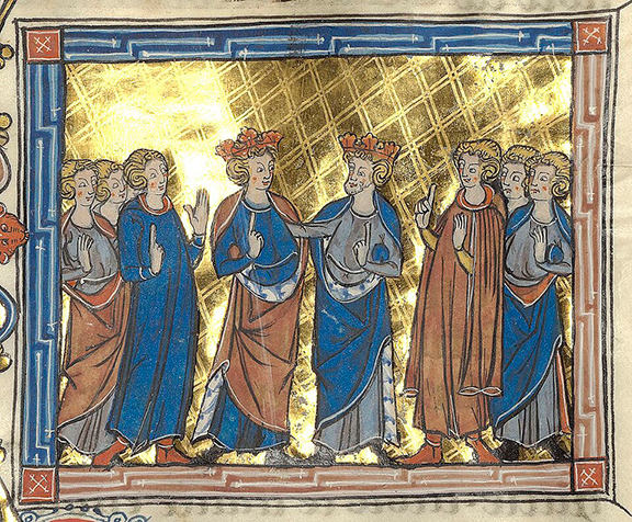
13th-century illumination of Philippe Auguste and Richard the Lionheart
Unknown artist, Philippe Auguste and Richard the Lionheart, 13th-century miniature, BnF, Français 2754, fol. 198. Public domain, via Wikimedia Commons.
Construction began on the Right Bank and continued on the Left Bank into the early thirteenth century. Richard and Philippe Auguste were crusading allies but also political rivals; Richard was technically the French king’s vassal, but as the King of England and with his vast lands in Aquitaine, Normandy and Anjou, he was the more powerful. The western approach to Paris was vulnerable to lands he held, and Philippe Auguste’s fortress at the Louvre helped defend that side of the city.[^7]
The Louvre (pictured later, so it may not have looked exactly like this when Philippe Auguste constructed it)
Limbourg brothers, October, from Les Très Riches Heures du duc de Berry, c. 1412–1416, Public domain, via Wikimedia Commons.
(Click to enlarge)
The Philippe Auguste wall protected the growing city on both banks of the Seine. It included established districts such as the Latin Quarter and the Halles, as well as open ground that could be developed as Paris grew. Four large towers guarded the river approaches, two on either side of the Seine to the east and west. Chains could be stretched across the river to block ships from entering or leaving the city.[^8]
The gates channelled movement along the roads leading out of Paris, and settlements—faubourgs—clustered along these approaches. One example was the Faubourg Saint-Jacques that grew along the road beyond the Porte Saint-Jacques on the Left Bank, the route south taken by pilgrims travelling to Santiago de Compostela. Growth was uneven: fields, gardens and religious estates still lay between the built-up areas.[^9]
The name of today’s Place de la Contrescarpe recalls the contrescarpe—the outer slope of the wall’s defensive ditch—near the old Porte Saint-Marcel (also called Bordet or Bordelle). Close by the gate stood the Pomme de Pin, a celebrated tavern traditionally associated with Rabelais (later) and the poets of the Pléiade. It seems that along the centuries the gate approach was a lively threshold between the walled city and its southern outskirts. (The square itself was created much later, in 1852.)[^10]
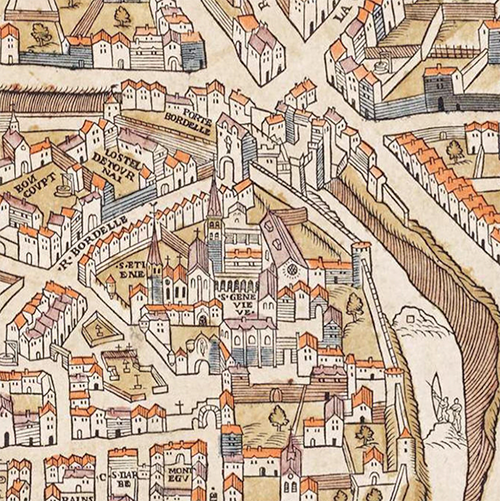
The Porte Saint-Marcel in 1550 (also called the Porte Bordelle, as we see here on this map); we can clearly see the Saint-Etienne du Mont church and the Abbey of Saint-Geneviève, part of which is now the Lycée Henri IV, and the “contrescarpe” and cluster of buildings the other side of the gate, including the inn supposedly frequented by Rabelais. This was the Philippe Auguste wall, strengthened further under Charles V .
Olivier Truschet and Germain Hoyau, La Ville, Cité et Université de Paris (Plan de Bâle), c. 1550–53; detail from the 1980 Seefeld facsimile, via Wikimedia Commons (public domain).
Many parts of Philippe Auguste’s wall can still be seen across Paris. The longest stretch is in the Marais, along Rue des Jardins-Saint-Paul, where a sports court runs beside the masonry. Young people of the Marais in the twenty-first century play ball in the shadow of the twelfth-century wall. That’s just so Parisian—remnants of the past are just part of the city we live our lives in today.
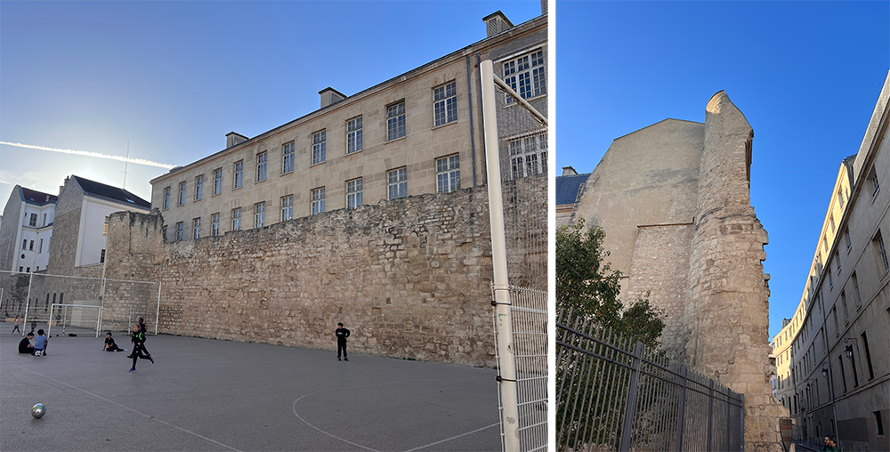
The Philippe Auguste wall on rue Jardins-Saint-Paul, 4ème
© Alannah Moore, Paris Footprints 2026
On the Left Bank, Rue Monsieur-le-Prince follows roughly the line of the wall; its former name, Rue des Fossés-Monsieur-le-Prince, recalls the defensive ditch. Here you can see the 1550 plan of Paris with the Philippe Auguste wall intact—I’ve highlighted the ditch leading up to the Porte Saint-Michel that later became the rue Monsieur-le-Prince. On the 1739 map below it, you can see the street in the place of the ditch, and that the gate has gone. (The Place Saint-Michel that you can see on that map at the top right is not the same one that we know—the one on the map is now Place Edmond Rostand by the Luxembourg Gardens.)
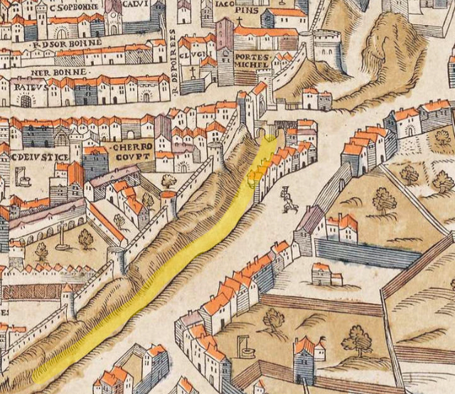
Olivier Truschet and Germain Hoyau, La Ville, Cité et Université de Paris (Plan de Bâle), c. 1550–53; detail from the 1980 Seefeld facsimile, via Wikimedia Commons (public domain).
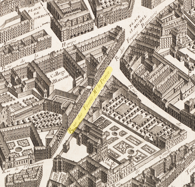
Detail from the Plan de Turgot, drawn by Louis Bretez and engraved by Claude Lucas, 1739. Source gallica.bnf.fr / Bibliothèque nationale de France. BnF- Bibliothèque nationale de France
Other remains include a huge visible chunk (below) jutting out onto the pavement on Rue Clovis in the 5th arrondissement which was revealed following a demolition in 1896, and a tower incorporated into a restaurant in Cour du Commerce-Saint-André in the 6th. There are numerous others throughout the city, some in courtyards, others in carparks or basements or incorporated into the back walls of apartment buildings—exploration of those is for another day![^11]
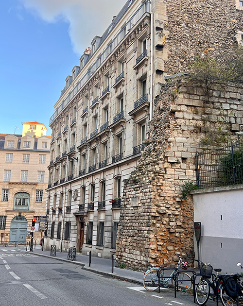
The Philippe Auguste wall on rue Clovis, 5ème
© Alannah Moore, Paris Footprints 2026
The wall of Charles V
By the fourteenth century, Paris had grown beyond the walls built by Philippe Auguste. The Hundred Years’ War brought the threat of attack closer, particularly after the French defeat at Poitiers in 1356. Work on a new wall began that year under the prévôt des marchands Étienne Marcel. Charles V resumed the project in 1365, and it was completed under his successor Charles VI, around 1420. The wall enclosed new districts on the Right Bank, including the Templar precinct and ground that would later become part of the Marais. On the Left Bank, where the city had grown less, sections of Philippe Auguste’s wall were repaired and strengthened, with ditches dug or renewed in front of it, but there was no necessity to enclose more land.[^12] The Charles V wall and its later westward extension, the Louis XIII or “Yellow Ditches” wall—or rather their ultimate removal—had a massive impact on the city, as we’re going to see.
This illumination from a manuscript (painted in Bruges, c. 1475) shows the Duke of Anjou with his mother, Marie of Blois, arriving in Paris via the Saint-Denis gate of the Charles V wall.
Master of Anthony of Burgundy, Arrival of Louis II of Anjou and Marie of Blois in Paris, c. 1475, from Froissart’s Chroniques, BnF, Français 2645, fol. 317 verso. Public domain, via Wikimedia Commons.
(Click to enlarge)
At the eastern approach on the Right Bank, Charles V had the fortress of the Bastille constructed to defend the city. It guarded the Porte Saint-Antoine and the road into Paris from the east. The gate and fortress shaped the convergence of streets here, a pattern still legible around today’s Place de la Bastille.[^13] Here you can see the Bastille in the 1550 map of Paris.
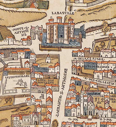
The Bastille and the Porte Saint-Antoine in the Charles V wall
Olivier Truschet and Germain Hoyau, La Ville, Cité et Université de Paris (Plan de Bâle), c. 1550–53; detail from the 1980 Seefeld facsimile, via Wikimedia Commons (public domain).
The old enclosure also left a striking imprint on the street plan. Along the eastern side, the elevated line of the rampart is today followed by boulevards Beaumarchais, des Filles-du-Calvaire and du Temple. Below them, Rue Amelot—formerly Rue des Fossés-du-Temple—runs along the low ground beside the old ditch. The difference in height between the boulevards and Rue Amelot, and the stairs connecting them, still reveal the earthworks that once stood here.[^14]
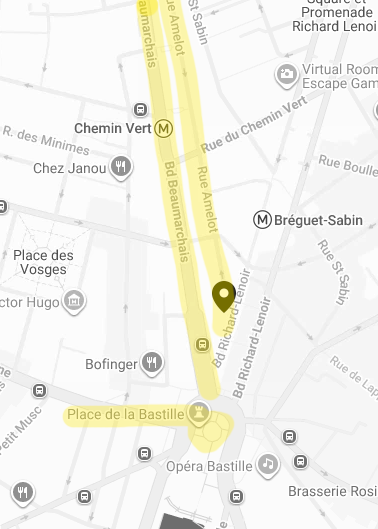
Rue Amelot, running parallel to Boulevard Beaumarchais, along the ditch and the rampart from Place de la Bastille
On the north-west side of the city, the route of the wall is also clearly visible in the street layout. Rue du Mail and Rue de Cléry follow the outer path beside the old ditch. Rue d’Aboukir, running parallel, ran in the ditch; one section of this street was once called Rue du Milieu-du-Fossé—“middle of the ditch”—and the difference in level is still noticeable today. When the wall and ditch were removed in the 1630s, the land was divided up and built over. The new streets became part of the Bonne-Nouvelle district, where workshops and artisans settled. Rue de Cléry, in particular, became known for woodworkers and furniture makers.[^15]
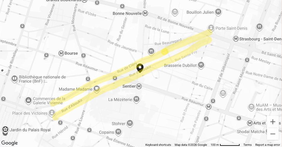
Rues du Mail and Cléry (you can’t see the label for Rue du Mail but it is the part nearest to Place des Victoires), running parallel to Rue d’Aboukir, along the path next to the ditch, and the filled-in ditch.
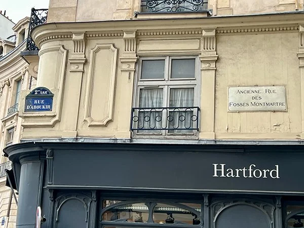
Rue d’Aboukir at the corner with Place des Victoires, showing the old street name for this section: Rue des Fossés Montmartre (ditch next to the Montmartre Gate).
© Alannah Moore, Paris Footprints 2026
The Fossés Jaunes: the Louis XIII enclosure
In 1566, during the Wars of Religion, Charles IX began strengthening the city’s defences. The new works adapted the walls to artillery. Along parts of the north and east, the existing wall of Charles V was reinforced with earth bastions. To the west, the defensive line moved outward, bringing more of Paris within its perimeter.[^16]
The work continued under Louis XIII and Richelieu, with major construction in the 1630s. In the west, the enlarged enclosure brought the Tuileries and the Faubourg Saint-Honoré within the defences; farther north, it took in the Faubourg Montmartre, around today’s Bourse district, and the Butte-aux-Gravois, a mound of rubble beyond the Charles V wall.
The enclosure became known as the enceinte des Fossés Jaunes (the “Yellow Ditches”), probably a reference to the colour of the earth dug from its ditches although this remains a little uncertain. The Richelieu district and the Palais Cardinal, later renamed the Palais-Royal, took shape in the area freed up by the destruction of the older walls.[^17]
The two enclosure lines are legible around Bonne-Nouvelle. We’ve seen how the parallel Rue du Mail/Rue de Cléry and Rue d’Aboukir trace the former Charles V wall and its filled-in ditch. The later Louis XIII wall brought the Butte-aux-Gravois, just next to these streets, within the expanded defences. High on the hillock, Rue Beauregard is traditionally said to take its name, “beautiful view,” from the panorama over the city and countryside once enjoyed from there; the buildings of Rue de la Lune also peered out from their vantage point over the wall towards the windmills of Montmartre. I read this in Eric Hazan’s The Invention of Paris and it comes to mind every time I walk along here—see the photos below—although today it is impossible to imagine any kind of country view.[^18]
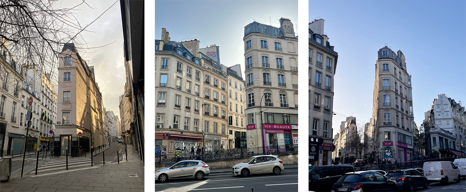
The junctions of Rue Cléry and Rue Beauregard (left), and Rue Cléry and Rue de la Lune (centre); a narrow block of apartments between Rue de la Lune and Rue Cléry where they meet the Boulevard de Bonne Nouvelle (right). Although the wall is long gone, the buildings do seem to peer down over the Boulevard below. You can clearly see the rise of the Butte-aux-Gravois; you also get the strong impression that the buildings are crammed into the space available to them behind the limits of the wall.
© Alannah Moore, Paris Footprints 2026
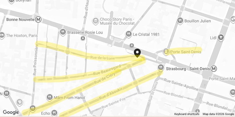
In the map below (1739), we can see the Porte Saint-Denis on the left, the tree-lined Boulevard de Bonne Nouvelle (not labelled on the map or perhaps the names were not yet assigned) and the Rue de la Lune, Rue de Beauregarde and Rue de Cléry; the street we can see called Rue de Bourbon would later become the rue d’Aboukir. At this point, the view beyond the Boulevard from the higher buildings would indeed have been over fields and gardens.
Detail from the Plan de Turgot, drawn by Louis Bretez and engraved by Claude Lucas, 1739. Source gallica.bnf.fr / Bibliothèque nationale de France. BnF- Bibliothèque nationale de France
(Click to enlarge)
Here is a picture of the new Porte Saint-Honoré, in the Louis XIII wall, with the Faubourg Saint-Honoré newly incorporated into Paris.
Adam Pérelle, L’an 1635, la nouvelle Porte St. Honoré, c. 1660. CC0 Paris Musées / Musée Carnavalet – Histoire de Paris.
(Click to enlarge)
By 1670, Louis XIV judged Paris sufficiently safe from threat. Recent conquests had pushed France’s frontiers farther from the capital; he ordered the demolition of the Charles V and Louis XIII fortifications. Broad, tree-lined promenades were laid out along their former lines, creating the Grands Boulevards we know today. The Grands Boulevards comprise the arc of boulevards on the Right Bank: Boulevard de la Madeleine, Boulevard des Capucines, Boulevard des Italiens, Boulevard Montmartre, Boulevard Poissonnière, Boulevard de Bonne-Nouvelle, Boulevard Saint-Denis, Boulevard Saint-Martin, Boulevard du Temple, Boulevard des Filles-du-Calvaire and Boulevard Beaumarchais, running from the Madeleine in the west to the Place de la Bastille in the east.
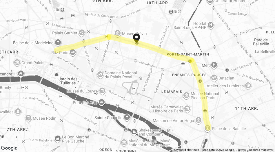
The arc of the Grands Boulevards created in place of the demolished walls.
The word boulevard comes from the Middle Dutch bolwerc, meaning a rampart or defensive work. As old ramparts became promenades, the word came to mean a broad street along which people could stroll—a long way from its original meaning. The idea of a tree-lined promenade was not new: Paris already had the Cours-la-Reine, created by Marie de Médicis in 1616 for fashionable promenading. What was new was the scale and setting: the old fortifications became an open promenade around the edge of the city.
The Grands Boulevards are now absolutely central in the city, so it is hard to imagine them marking the edge of Paris. For much of the eighteenth and nineteenth centuries, they were among Paris’s most fashionable places to see and be seen.[^19]
Many of the city’s famous boulevards were constructed much later, under Napoleon III, and necessitated the massive destruction of existing buildings. However, the demolition of the city walls under the Sun King, and the transformation of that space into open promenades for citizens, was the true beginning of the Parisian boulevard.
Three nineteenth-century paintings of the Grands Boulevards; click to see larger
Camille Pissarro, The Boulevard Montmartre on a Winter Morning, 1897. Oil on canvas. The Metropolitan Museum of Art, New York, 60.174. Public domain.
Claude Monet, Boulevard des Capucines, 1873–74. Oil on canvas. The Nelson-Atkins Museum of Art, Kansas City, F72-35. Public domain.
Jean Béraud, Le boulevard des Capucines, le soir, devant le Café Napolitain, c. 1880. Oil on canvas. Musée Carnavalet – Histoire de Paris, Paris Musées, P1659. CC0.
The monumental and impressive triumphal arches of Porte Saint-Denis and Porte Saint-Martin were built on the sites of the former gates; they are purely symbolic monuments, not gates through which traffic ever passed or customs were levied.[^20].
The images below show three views of the Porte Saint-Denis. The first is a sketch of the medieval gate in the Charles V wall, which was demolished. The second is a painting from 1680 of the triumphal arch that we know; it looks exactly as it does now, minus the traffic jams. The third image, a Belle Époque street scene by Jean Béraud from 1875, looks remarkably familiar.
From Dictionary of French Architecture from 11th to 16th Century (1856) by Eugène Viollet-le-Duc (1814-1879). Public Domain, https://commons.wikimedia.org/w/index.php?curid=896855 (left)
Par École d’École française de peinture — Paris Musées, Domaine public, https://commons.wikimedia.org/w/index.php?curid=98002969 (centre)
Par Jean Béraud — https://www.paintingmania.com/le-boulevard-st-denis-paris-220_33407.html, Domaine public, https://commons.wikimedia.org/w/index.php?curid=1350726 (right)
(Click to enlarge)
And here we have the Porte Saint Martin. First, a later sketch of the old gate in the Charles V wall; in the middle, an 1829 watercolour of the triumphal arch that replaced it that is still there today, and on the right, a poignant Bastille Day Ball in front of the arch in July 1914.
By Pernot, François Alexandre (Wassy, 15–02–1793 - Wassy, 03–11–1865), dessinateur - https://www.parismuseescollections.paris.fr/fr/musee-carnavalet/oeuvres/ancienne-porte-saint-martin, CC0, https://commons.wikimedia.org/w/index.php?curid=136063512 (left)
By Christophe Civeton - This file comes from Gallica Digital Library and is available under the digital ID btv1b10302432t, Public Domain, https://commons.wikimedia.org/w/index.php?curid=7693949
Bal du 14 juillet porte Saint-Martin à Paris. http://gallica.bnf.fr/ark:/12148/btv1b6930829x.r.langFR By Agence Rol - Photo ancienne, Public Domain, https://commons.wikimedia.org/w/index.php?curid=37828258 (right)
(Click to enlarge)
The wall of the Farmers-General
The wall of the Fermiers généraux, built between 1784 and 1791, marked a different kind of boundary. Its purpose was to collect octroi—tax on goods entering Paris—not to defend the city. The Ferme générale was a private body of financiers contracted by the Crown to collect certain taxes; the “farmers” were tax farmers, nothing to do with agriculture. The architect Claude-Nicolas Ledoux designed the barriers and tollhouses along the wall.[^21]
The tax applied to everyday goods, including alcohol, meat, flour, fish, oil and firewood. Merchants passed the extra cost on to their customers, so Parisians ultimately paid more for what they bought. Obviously, the wall was deeply unpopular. Just beyond its barriers, guinguettes—drinking and dancing places—clustered around Montmartre and the “Courtille” at Belleville (then a rural district of vineyards and gardens). Parisians crossed the tax boundary to eat, drink and dance, with wine especially cheaper outside the city’s reach. A similar entertainment district grew up near the Barrière du Maine, where Rue de la Gaîté became known for its cafés, cabarets and theatres.[^22]
It’s hard today to imagine that areas such as Montmartre, Belleville or the southern part of Montparnasse were separated from Paris by just a wall. As an example, standing at the foot of the garden in front of Sacré Coeur, where there is a carrousel, look back down towards the Métro Anvers, just a few hundred metres, and the wall was right there!
The picture below on the left shows dancers from the Courtille, and the painting on the right shows early morning revellers returning through the octroi gates into Paris after a Mardi Gras party .
Anonymous, Les amusements de la Courtille, undated, coloured etching. Musée Carnavalet – Histoire de Paris, Paris Musées, G.24488. CC0.
Charles Nanteuil, La descente de la Courtille, 1842. Oil on canvas. Musée Carnavalet – Histoire de Paris, Paris Musées, P1567. CC0.
(Click to enlarge)
Here we can see an early photo of the famous Moulin de la Galette dance hall in Montmartre, established under octroi restrictions, later immortalised by Renoir’s painting Bal du Moulin de la Galette.
Anonymous photographer, Le Moulin de la Galette, moulin Radet au premier plan et moulin Blute-Fin à l’arrière-plan, Montmartre, 1845–55. Salted-paper print. Musée Carnavalet – Histoire de Paris, Paris Musées, PH4130. CC0.
(Click to enlarge)
The tax wall was gone by the time Renoir painted this, but it was the reason Montmartre had become a destination for leisure.
Pierre-Auguste Renoir, Bal du moulin de la Galette, 1876. Oil on canvas. Musée d’Orsay, Paris, RF 2739. Photograph by Rainer Halama, via Wikimedia Commons, CC0.
(Click to enlarge)
By then, Paris was already surrounded by faubourgs: communities outside its official limits but closely connected to it. Just as the Louis XIII and Charles V walls directly impacted the city’s street layout in creating the Grands Boulevards, the tax wall’s route is still legible in the chain of boulevards that curve around the city on both banks (further out than the Grands Boulevards on the Right Bank). On the north and east, these include the boulevards de Clichy, Rochechouart, La Chapelle, La Villette, Belleville, Ménilmontant and Charonne. On the south, the line runs along boulevards including Vincent-Auriol, Auguste-Blanqui, Saint-Jacques, Raspail, Edgar-Quinet, Montparnasse and Pasteur. The route shifted in places, so these streets do not form a perfectly continuous or exact trace. The Métro gives a useful sense of its shape: line 2, from Porte Dauphine to Nation, follows the northern arc, while line 6, from Charles de Gaulle–Étoile to Nation, follows the southern one, broadly echoing the old circuit.[^23]
Métro lines 2 and 6 roughly follow the line of the tax wall.
By Rigil - Own work, CC BY 3.0, https://commons.wikimedia.org/w/index.php?curid=8373237
(Click to enlarge)
Some of Ledoux’s tollhouses also survive, including the Rotonde de la Villette, the pavilions of the Barrière d’Enfer at Denfert-Rochereau and the columns of the Barrière du Trône near Nation.
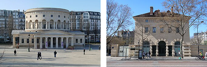
Two existing tollhouses by Ledoux, on the left the Rotonde de la Villette, and on the right, the Barrière d'Enfer, at Place Denfert-Rochereau
By Coyau / Wikimedia Commons, CC BY-SA 3.0, https://commons.wikimedia.org/w/index.php?curid=18490602 (left)
By Polymagou - Own work, CC BY-SA 4.0, https://commons.wikimedia.org/w/index.php?curid=133647630 (right)
This is an engraving from 1787 of the Barrière du Trône at today’s Place de la Nation; the columns are still there, and the pavilions are used as social housing.
By Pierre Nicolas Ransonnette - Agence Rol, Public Domain, https://commons.wikimedia.org/w/index.php?curid=156481455
(Click to enlarge)
The Thiers fortifications
In the nineteenth century, Paris acquired its last great fortified enclosure: the wall of Thiers, built between 1841 and 1845. The allied occupation of Paris in 1814, after the Battle of Paris, had shown how vulnerable the capital was. The allies occupied it again in 1815, after Napoleon’s defeat at Waterloo. The Eastern Crisis of 1840, which left France diplomatically isolated, renewed fears of invasion.[^24] Ordered under King Louis-Philippe, the project was championed by Adolphe Thiers, then head of government, whose name the wall took. With 94 bastions, it was known colloquially as les fortifs.
Seen here, Porte de Bagnolet in the 20th arrondissement, and the Poterne des Peupliers in the 13th.
Eugène Atget, Poterne des Peupliers, les fortifications, boulevard Kellermann, 1910. Photograph. Musée Carnavalet, Paris Musées, PH8369. CC0.
(Click to enlarge)
A broad no-building zone was left just outside the fortifications. Over time, poor families, workers, migrants and ragpickers built homes and makeshift settlements there. Its inhabitants became known as zoniers, and “the Zone” acquired a distinctive place in the Paris imagination: rough, bohemian, marginal and sometimes criminal, but also full of life.
The Zone: shacks of rag pickers outside the fortifications.
Eugène Atget, Poterne des Peupliers, zone des fortifications, chiffonniers, 1913. Photograph. Musée Carnavalet, Paris Musées, PH8363. CC0.
(Click to enlarge)
The Thiers fortifications left two concentric routes around Paris. Just inside the wall, the old military road became the Boulevards des Maréchaux—a chain of ordinary city streets that circle Paris just inside the main ring road. Outside it, the Périphérique (the ring road, a fast, busy, multi-lane autoroute) was built much later through the former Zone, the strip of land where building had been restricted. The names of the old openings survive in today’s portes (ring road exits), including Porte de Clignancourt, Porte d’Orléans, Porte de Vincennes and Porte de Vanves.[^25] At these points, slipways and ramps cross the line where the nineteenth-century wall once stood.
In 1860, Paris annexed the communes that had also been included within the ring of the fortifications, including Belleville, Montmartre, Passy, Vaugirard, and all of Montparnasse, which were not at that time part of Paris. The city’s administrative boundary moved outwards, its twelve arrondissements became twenty, and the Farmers-General wall was demolished.[^26] Places that had been separate villages became Paris neighbourhoods, each bringing its own history and character into the enlarged city.
Here’s a picture of one of the hated tax barriers being demolished; this one was at Pigalle.
Hintz, Barrière Pigalle, démolition des murs de l’ancien octroi de Paris, c. 1860. Wood engraving. Musée Carnavalet – Histoire de Paris, Paris Musées, G.38246. CC0.
(Click to enlarge)
Only ten years later, the Thiers fortifications faced a real test. During the Franco-Prussian War, Prussian-led German forces encircled Paris from September 1870 to January 1871. The city’s defenders manned the wall and its outer forts, but the siege cut Paris off from supplies and eventually forced it to capitulate. As food ran short, Parisians ate horse meat, then cats, dogs and even rats. Some zoo animals were also slaughtered; their meat appeared on the menus of a few luxury restaurants, far beyond the reach of most Parisians. With normal communications severed, manned gas balloons carried mail and dispatches out of the city.
The fortifs in use in December 1870
Anonymous photographer, Siège de Paris, travaux de défense (8e secteur), vue prise de la caserne près la Porte d’Orléans (Bastion 79), 3 December 1870. Albumen print. Musée Carnavalet, Paris Musées, PH38049. CC0.
(Click to enlarge)
It is astonishing to think that, a little over 150 years ago, Parisians, people to whom we can relate through their writing and their art (Victor Hugo, Alphonse Daudet, Manet, Degas…) endured a siege—an experience we tend to associate with much earlier centuries.[^27]
The fortifications were drawn into another kind of siege just months later. During the Commune of 1871, the Versailles army—the French government troops—bombarded the Thiers wall and the forts defending western Paris. Shells struck nearby neighbourhoods, including the area around the Avenue de la Grande-Armée. The fortifs had been built to defend the capital; now they were part of a civil war fought at its edge.[^28]
An 1871 wood engraving of the insurgents defending Porte Maillot
Anonymous, Souvenirs de la Commune – Défense de la porte Maillot par les insurgés, 1871. Wood engraving, published in L’Univers illustré. Musée Carnavalet, Paris Musées. CC0.
(Click to enlarge)
The Thiers wall was finally demolished between 1919 and 1929. Construction of the Boulevard Périphérique began in 1956, and it opened in 1973, following much of the old fortification’s route.[^29]
The Zone is gone, but its legacy remains around the Périphérique: open plots and isolated neighbourhoods occupy land shaped by the fortifications and by the roads, railways and housing that followed.
Paris’s walls did more than defend the city. They determined which districts lay inside its limits, where goods were taxed and where Parisians went for cheaper wine and entertainment. Their ditches, ramparts and cleared ground became streets and boulevards; even after the walls came down, they continued to shape the city’s layout and its relationship with the places beyond it.
That divide is still reflected in the terms intra-muros and extra-muros—within the walls or outside them—terms which are used daily by Parisians. The Périphérique broadly follows the line of the Thiers fortifications, though the administrative boundary does not match the road exactly. Near the ring road, traffic, noise, air quality and property values can change noticeably; the Périphérique also interrupts local routes, channelling crossings between Paris and its neighbours through bridges, underpasses and the portes. The Grand Paris Express and plans to transform the Périphérique aim to improve connections across this edge and strengthen links with neighbouring communes.[^30] The history of Paris’s walls is also a history of the city’s continuing effort to connect with what lies beyond them.
Footnotes and References
[^1]: Eric Hazan, The Invention of Paris: A History in Footsteps, translated by David Fernbach (London and New York: Verso, 2010), especially pp. 13–16, on Paris’s growth in “concentric rings, like an onion.” The French original is L’invention de Paris : il n’y a pas de pas perdus (Paris: Seuil, 2002). Bibliothèque nationale de France catalogue; Hazan’s essay in New Left Review.
[^2]: Ville de Paris, Département d’histoire de l’architecture et d’archéologie de Paris (DHAAP) and Inrap, “Découverte archéologique : le rempart de la Lutèce gauloise sous l’Hôtel-Dieu à Paris”, 23 September 2026. It reports the roughly 20-metre stone-and-wood structure, its construction technique and the preliminary radiocarbon range of 200–10 BC.
[^3]: The same 2026 archaeological announcement says the wall’s function and exact construction date remain under investigation, and that its burning cannot yet be securely linked to Caesar’s account. For Caesar’s account of Lutetia being burned under the command of Camulogenus, see Commentarii de Bello Gallico, VII.57, Latin text. Caesar does not identify the newly found wall; that connection remains a hypothesis.
[^4]: For the Roman urban centre on the Left Bank, later activity on the Île de la Cité, reuse of stone from abandoned monuments, and the late Roman enclosure, see Ville de Paris, “Les 7 enceintes de Paris”, and the Crypte archéologique, “Plus de 2000 ans d’histoire”. “Less than ten hectares” is an approximate reconstruction of the fortified island settlement.
[^5]: The Crypte archéologique de l’île de la Cité documents the Roman river port and early-fourth-century enceinte beneath the parvis. For the island’s altered shoreline and the limits of earlier archaeological evidence, see the Ministry of Culture, “La Lutèce gauloise”. The present bank line is not a direct guide to the Roman shoreline; the island’s edges were substantially reshaped by later works.
[^6]: Inrap, “La première enceinte médiévale de la rive droite à Paris”, report on the excavation at 144 Rue de Rivoli. The ditch was about 10 metres wide and 3 metres deep; its pottery includes Carolingian material, but the report says the date cannot be determined precisely and only proposes a possible connection with the period of the Norman attacks. The article’s range, 978–998, should therefore be read as a historical estimate, not a date established by the excavation. “Carolingian” refers broadly to the eighth through tenth centuries.
[^7]: Ville de Paris, “Sur la piste de l’enceinte médiévale Philippe-Auguste, rive droite”, on the 1190–1210 construction, Louvre fortress (1190–1202), and western threat; and the Ministry of Culture’s Mérimée record. Philippe Auguste left for the Third Crusade in 1190; he and Richard were crusading allies as well as political rivals.
[^8]: The Ville de Paris’s Right Bank guide to the Philippe-Auguste enceinte describes the river chains, carried on boats, and other river defences. For the wall’s two-bank extent and surviving remains, see the City’s Left Bank guide.
[^9]: For the wall, its gates and the changing urban fringe, see the Ville de Paris guides to the Right Bank and Left Bank. Paris was on the Via Turonensis, the route from Paris through Tours toward Compostela; see the French Ministry of Culture’s map of Santiago routes. The reference is to the road out of the city.
[^10]: The City of Paris’s official list of old street names identifies Porte Bordelle/Bordet as another name for Porte Saint-Marcel. Contrescarpe refers to the outer slope of a defensive ditch. The Pomme de Pin’s associations with Rabelais and the Pléiade are traditional literary lore.
[^11]: Ville de Paris, Left Bank guide, documents the Rue Clovis stretch and explains that the apparent intrusion into the pavement results from the later pavement line. The Right Bank guide identifies the nearly 80-metre stretch beside the Collège Charlemagne sports court. It says pupils from the neighbouring school use the court; it does not describe it as a general neighbourhood sports court. The City guides also locate further remains.
[^12]: Paul Van Ossel, “Nouvelles données sur l’enceinte de ‘Charles V’ (XIVe–XVIe s.) à Paris”, Comptes rendus des séances de l’Académie des Inscriptions et Belles-Lettres 136, no. 2 (1992), pp. 337–351. It dates Étienne Marcel’s initial works to after Poitiers (1356), with work documented from 1358; Charles V resumed the project in 1365, and it was completed around 1420 under Charles VI. This enceinte was built on the Right Bank; on the Left Bank the older line was strengthened rather than replaced.
[^13]: For the Bastille’s role in the Charles V enceinte and its place guarding the eastern entrance, see Ville de Paris, “Les 7 enceintes de Paris”, and the historical study Vincennes aux origines de l’État moderne, which maps the right-bank enclosure and the districts it included.
[^14]: The City’s “Les 7 enceintes de Paris” and Van Ossel’s archaeological study document the line of the Charles V enceinte. Rue Amelot’s former name, Rue des Fossés-du-Temple, and its lower level alongside raised boulevards are also described in this historical account of Rue Amelot; the street-name evidence is consistent with the visible topography.
[^15]: Van Ossel’s study identifies the Charles V line along Rue du Mail and Rue d’Aboukir; the Atlas historique de Paris helps situate the north-western boundary. The precise line differs by block, so “follow” describes the surviving street pattern rather than a wall preserved continuously beneath both streets. The artisan/workshop history of the Bonne-Nouvelle streets is discussed in Jacques Hillairet, Dictionnaire historique des rues de Paris (Paris: Éditions de Minuit), entries “Cléry” and “Aboukir.”
[^16]: Ville de Paris, “Les 7 enceintes de Paris”, explains the artillery-driven reinforcement and the western extension from 1566, enclosing the Tuileries and growing districts. The name Fossés Jaunes is generally linked to the colour of excavated earth, though the explanation is not certain.
[^17]: APUR, Paris Projet n° 4: Espaces verts dans Paris / Pour une renaissance du Palais-Royal, on the 1633–1636 Louis XIII enclosure and the development of the Richelieu quarter on former fortification land. The Palais Cardinal was built for Richelieu and became the Palais-Royal after it passed to the Crown.
[^18]: Hazan, The Invention of Paris, describes the view from the Butte-aux-Gravois toward the countryside and Montmartre’s windmills; the explanation of Rue Beauregard’s name as “beautiful view” is traditional. This sentence combines Hazan’s historical image with my present-day observation, rather than claiming the view can be verified from the modern street geometry.
[^19]: Ville de Paris, “De porte en porte, Paris se raconte”, explains Louis XIV’s 1670 decision to remove obsolete fortifications after territorial conquests and replace them with a planted promenade. An earlier precedent was the Cours-la-Reine, created by Marie de Médicis in the early seventeenth century; see Ville de Paris, “L’arbre à Paris au fil du temps”. The Académie française traces boulevard to Middle Dutch bolwerc, “bastion” or “fortification,” and records its later meanings as a tree-lined promenade and broad street: “Boulevard”. See also Hazan, The Invention of Paris.
[^20]: Ville de Paris, “À la découverte des arcs de triomphe parisiens”, on the Porte Saint-Martin and Porte Saint-Denis monuments, their dates and relationship to the former gates. The monuments replaced the medieval gates as symbolic landmarks; they were not customs gates.
[^21]: Ville de Paris, “De porte en porte, Paris se raconte”, dates the tax wall to 1785. The Paris Catacombs’ official history, “L’architecture”, explains the Ferme générale’s tax-collection role and Ledoux’s designs for its barriers. “Farmers” translates fermiers in the fiscal sense; it does not refer to agriculture.
[^22]: For octroi and the tax wall, see Renaud Gagneux and Denis Prouvost, Sur les traces des enceintes de Paris (Paris: Parigramme, 2004), and “Le mur des Fermiers généraux en 1790”, which cites the period tariff and archival research. For guinguettes outside the tax line around Belleville and the Courtille, see the Mairie du 20e, “L’histoire économique du 20e”, “Les guinguettes de Belleville”, and the Musée Carnavalet record for La Descente de la Courtille. The Courtille was a rural locality on Belleville’s hillside, with vineyards, gardens, taverns and guinguettes. Rue de la Gaîté’s entertainment venues grew outside the Barrière du Maine; see the Archives nationales street record.
[^23]: The wall’s route is mapped in the City of Paris’s “Les 7 enceintes de Paris”. RATP explains that line 2 traces the northern arc and line 6 the southern arc of the former wall: line 2 history and line 6 history. The surviving Ledoux buildings are described by the Paris Catacombs and the City’s “De porte en porte” guide.
[^24]: Ville de Paris, “Un bastion de l’enceinte de Thiers exhumé”, documents the 94 bastions and the 1840s construction. Dates are variously given as 1841–1844 or 1841–1845, depending on whether they refer to principal works or final completion. For the political context of the 1840 Eastern Crisis and France’s isolation, see Larousse’s history of the July Monarchy and James L. Richardson, “The Eastern Crisis, 1839–1841”.
[^25]: For the non-construction zone and zoniers, see Archives de Paris, “Variété des usages de la photographie dans les fonds des Archives de Paris”, and the Musée national de l’histoire de l’immigration, “Le fonds photographique de la Zone”. The named portes are historic openings in the Thiers enceinte; today’s road junctions and Périphérique slip roads do not necessarily reproduce every gate’s exact footprint.
[^26]: Archives de Paris, “Plans parcellaires”, states that on 1 January 1860 Paris annexed neighbouring communes in whole or in part, grew from 12 to 20 arrondissements, and moved its boundary to the Thiers fortifications. The eleven fully annexed communes are listed in the Archives’ “Communes annexées”.
[^27]: Ville de Paris, “Lorsque Paris était assiégée par les Prussiens en 1870”, documents the siege from September 1870 to January 1871 and the repair and manning of the Thiers enceinte. The siege demonstrates that the fortifications had active defensive use; the city ultimately capitulated after the blockade and bombardment. For shortages and the eating of horses, cats, dogs, rats and zoo animals, see the City’s “5 techniques pour survivre pendant un siège à Paris”. For balloon-post correspondence, see the Bibliothèque historique de la Ville de Paris records in the Catalogue collectif de France and Musée Carnavalet’s postal balloon record.
[^28]: For archival records concerning the Commune and the Versailles army’s operations, see Archives de Paris, “Commune de Paris”, and the Service historique de la Défense, “Guerre de 1870-1871, Commune de Paris”.
[^29]: Ville de Paris, “De porte en porte, Paris se raconte”, gives the Périphérique’s construction dates and its relationship to the Thiers line.
[^30]: Ville de Paris, “De la ceinture grise à la ceinture verte”, describes current aims to improve connections with neighbouring communes and transform the Périphérique corridor. The Grand Paris Express is a separate regional rail project.