If you stand with your back to Boulevard Saint-Germain and look down Rue de la Harpe, the contrast is striking.
Behind you is a grand, spacious nineteenth-century boulevard, lined with trees and filled with traffic. Ahead, Rue de la Harpe is narrow and slightly crooked, with façades from different periods jostling together beneath an uneven roofline. It might look like another small, ancient Latin Quarter street that happens to have survived beside two major boulevards. But in fact, you’re looking at a fragment of what was once one of the Left Bank’s main north–south thoroughfares, running parallel to Rue Saint-Jacques.[^1]
Like many old Paris streets, it has had different names along different stretches. What eventually became Rue de la Harpe once ran from Rue de la Huchette uphill to the medieval Porte Saint-Michel, also called Porte Gibard or Porte d’Enfer, in Philippe Auguste’s city wall (built around 1200). The gate stood near today’s junction of Boulevard Saint-Michel and Rue Monsieur-le-Prince, right next to the Luxembourg Gardens.[^2] Rue de la Harpe lost roughly two-thirds of its length, shrinking from 635 metres to 220 metres.[^3] Much of its southern stretch disappeared in the 1850s to make way for the boulevard, initially called Boulevard de Sébastopol, Rive Gauche. It became Boulevard Saint-Michel in 1867.[^4]
Rue de la Harpe taken from the junction with Rue Saint-Séverin
The name Rue de la Harpe appears in records from 1247. It’s usually attributed to a sign showing a harp, sometimes said to have depicted King David playing it, though the explanation isn’t certain.[^5] In medieval times, with the Left Bank at the centre of university life, the street belonged to a busy world of students, clerics, teachers, lodging houses, booksellers and inexpensive places to eat. The colleges of Justice, Harcourt, Dainville, Séez, Narbonne and Bayeux stood along its route. The Lycée Saint-Louis now occupies the site of the Collège d’Harcourt, but the others are long gone, in the name of nineteenth-century urban planning.[^6]
I often wonder how different the Latin Quarter would have felt several centuries ago. There would have been plenty of bustle and activity, with students from across France and abroad finding lodgings and making their way to lectures. The students could be rowdy—reports of student disturbances go right back to medieval times. But there was also a strong clerical presence, with the Church and the university closely bound together.[^7] Today, much of the bustle comes from foreign tourists, rather than the students and clerics who once filled these streets.
Some things feel surprisingly familiar. Records from the late seventeenth century show that the Collège de Bayeux rented a shop on Rue de la Harpe to a rôtisseur, a seller of cooked roast meat. They suggest that he supplied the college’s scholarship students with meals at below-market prices.[^8] I love this little glimpse of everyday student life: even then, there were arrangements to help students get an affordable meal. (I also came across a story about meat roasting on spits in neighbouring Rue de la Huchette—an echo of the kebab shops dotted around these pedestrian streets today—but that’s for another day.)
Here are some drawings of the doorway of the Collège de Bayeux, founded in 1308; the doorway is now in the Cluny Museum.
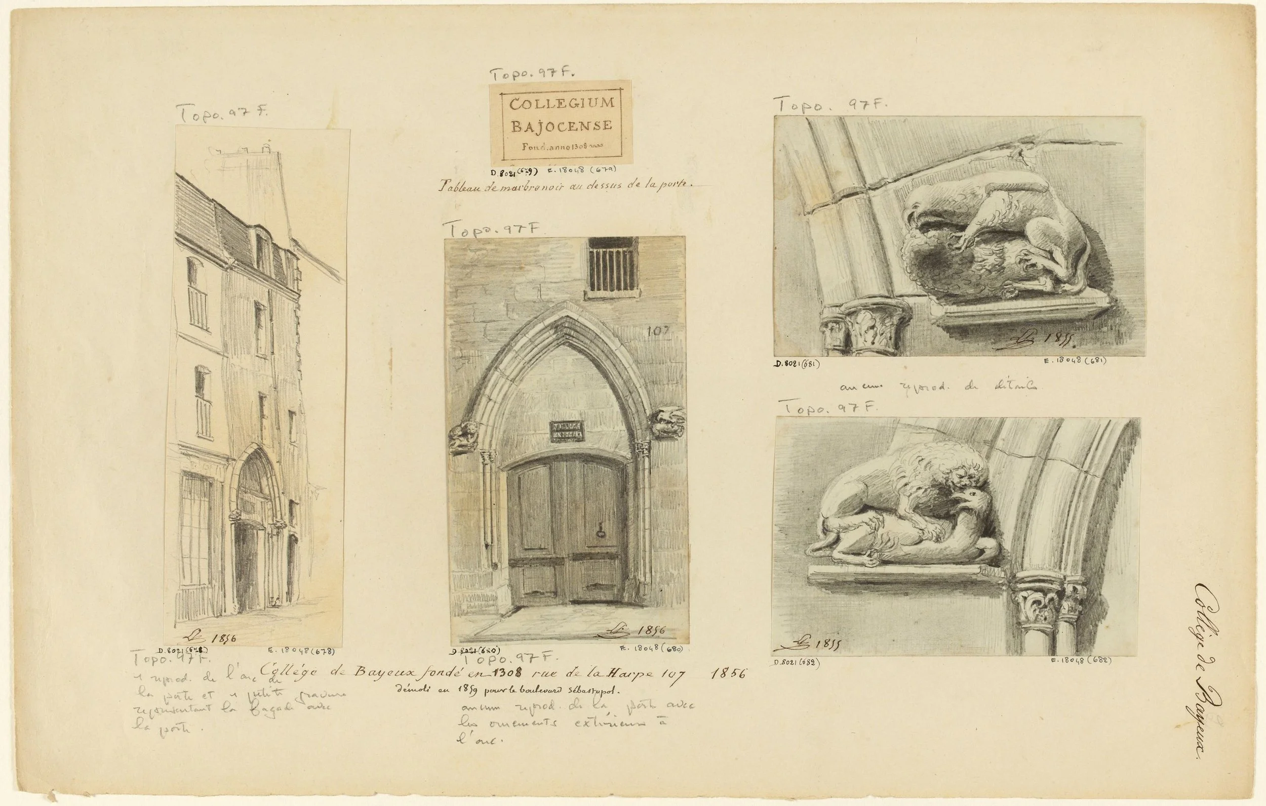
Léon Leymonnerye, Collège de Bayeux: doorway and architectural details, 1855–1856. Paris Musées / Musée Carnavalet – Histoire de Paris. CC0.
And here is the beautiful doorway of the Collège de Narbonne, established 1317, rebuilt 1780 and demolished in 1859.
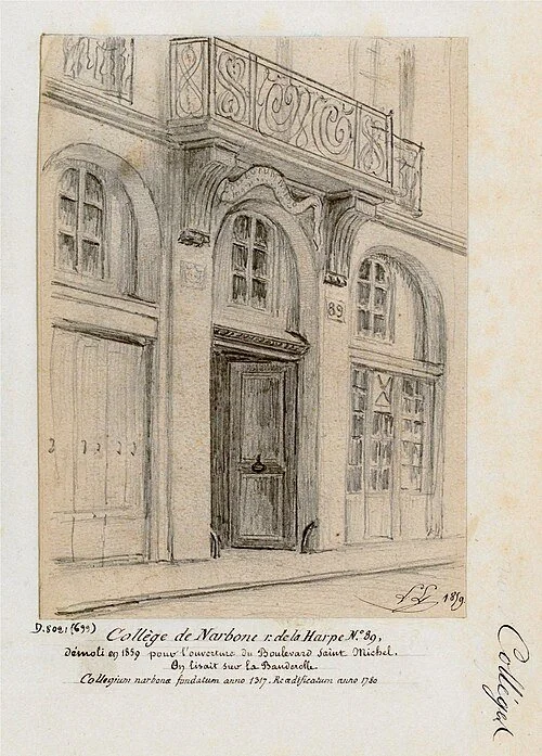
Léon Leymonnerye, Collège de Narbonne, 89 Rue de la Harpe, 1859. Musée Carnavalet – Histoire de Paris, via Wikimedia Commons. Public domain.
On the Truschet map of Paris (1550) we can clearly see the Sorbonne on Rue Saint-Jacques and the Bayeux, Narbonne, Harcourt and Justice colleges of the Rue de la Harpe. We can also see the medieval gateway of Saint-Michel, demolished in the 17th century when the city had long outgrown it, and both the church of Saint-Côme and the Hôtel de Cluny (now the Cluny Museum; is the stripy building the bathhouse?)—which I’ll come to in just a moment.
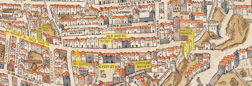
Olivier Truschet and Germain Hoyau, La Ville, Cité et Université de Paris (Plan de Bâle), c. 1550–53; detail from the 1980 Seefeld facsimile, via Wikimedia Commons (public domain).
Here is the Collège d’Harcourt, seen on on the Turgot map of Paris (1739). Apparently there is just one doorway remaining from the old building, now incorporated within the newer building of the Lycée Saint-Louis.
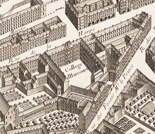
Detail from the Plan de Turgot, drawn by Louis Bretez and engraved by Claude Lucas, 1739. Source gallica.bnf.fr / Bibliothèque nationale de France. BnF- Bibliothèque nationale de France
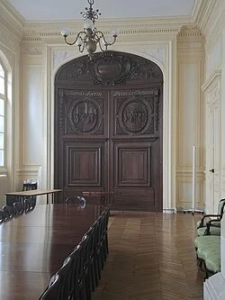
Doorway from the former Collège d’Harcourt, preserved in the Lycée Saint-Louis. Photograph: Resp56, 2024; perspective corrected by Polymagou, via Wikimedia Commons. CC BY-SA 4.0.
Here is Rue de la Harpe seen from the Rue de la Huchette end, photographed by Charles Marville around 1866, a few years after the southern stretch disappeared.[^9]
Rue de la Harpe by Charles Marville
Charles Marville, Rue de la Harpe, viewed from Rue de la Huchette, 1865–1868. Paris Musées / Musée Carnavalet – Histoire de Paris. CC0.
Compare it with my photograph of the street today.
Rue de la Harpe today. This section of the street was previously called Rue de la Vieille-Bouclerie and officially attached to Rue de la Harpe in 1851.
© Alannah Moore, Paris Footprints 2026
Not a lot has changed. Where the street bends to the right, the house on the left with the dormer windows seems to have acquired an extra storey. I deliberately stood a little farther back than Marville to give context to the large blank wall. Today it has graffiti on it; in his photograph it carries advertisements for local businesses, including something to do with metal at the top, which I can’t quite understand, then biscuits and gingerbread, which is clearly a baker—and can that be accordion sales and repairs at the bottom?
The sudden change in the building alignment is a detail worth noticing. Nos. 1 and 3 (which is the main building housing the supermarket, invisible in Marville’s photo) stand farther back, while no. 5 is much nearer to the road. This is the trace of a widening scheme that was never completed.[^10] Over the centuries, the authorities repeatedly tried to make Paris’s narrow streets easier for people, horses, carts and carriages to negotiate. You can imagine how blocked the narrow streets would have become, especially seeing as there were no wider thoroughfares, as there are today, to take the mass of the traffic. As houses were rebuilt, their replacements could be required to stand a certain distance farther back from the road in order to widen it. When you can see a building jutting out nearer the road than its neighbours, as we can see here, it means it has not been rebuilt (or demolished) and is therefore significantly older.[^11]
This second Marville photograph looks from the other end of the surviving street, with Boulevard Saint-Germain behind the photographer.
Charles Marville, Rue de la Harpe, viewed from Boulevard Saint-Germain, 1865–1868. Paris Musées / Musée Carnavalet – Histoire de Paris. CC0.
And here is my photograph taken from the same position.
Rue de la Harpe, seen from the Boulevard Saint-Germain end of the street
© Alannah Moore, Paris Footprints 2026
In Marville’s time, the tiny corner shop on the right bought and sold silverware.[^12] In my photograph, the supermarket uses the same spot to sell sandwiches. The window above it to the right is now partly blocked and used as an air vent. Otherwise, apart from the large Vélib’ stand on the left, the scene is remarkably similar.
There was a widening planned for this end of the road too. We can see that the building now occupied by McDonald’s stands farther back than its neighbours, which is why there’s space for that little corner shop. The alignment was happily never imposed, and several handsome eighteenth-century buildings were spared demolition.[^13]
Charles Lansiaux, Ground floor and mezzanine, 35 Rue de la Harpe, c. 1917. Paris Musées / Musée Carnavalet – Histoire de Paris. CC0. Paris Musées
35 Rue de la Harpe
© Alannah Moore, Paris Footprints 2026
This is the handsome Louis XV building at no. 35, built in 1730, photographed in 1917 and then by me today: a restaurant on the ground floor then as now; I couldn’t match the old viewpoint because of parked cars. Its façade and roof facing Rue de la Harpe are protected, along with the staircase and its wrought-iron balustrade.[^14]
45 Rue de la Harpe
© Alannah Moore, Paris Footprints 2026
No. 45, seen above, with its monumental doorway and sculpted bearded faces, has an interesting story attached to it. In 1741, the architect François Debias-Aubry was commissioned to build it for a notary, Nicolas Juliennet. The building costs reportedly proved too much for him, and in 1751 he had to sell it to Jean-Baptiste-Albert Baillon, a clockmaker who held the title of first valet de chambre to Queen Marie Leszczyńska, Louis XV’s wife.[^15] What a massive and sad disappointment that must have been. You can still see his initials, NJ, in the ironwork of the first-floor window guards.
Turning around and looking across Boulevard Saint-Germain, opposite the end of the surviving street, you can see the Thermes de Cluny, the Roman baths now incorporated into the Musée de Cluny. Rue de la Harpe must have veered quite significantly to go around them. The enormous remains were part of the neighbourhood’s everyday life. The great vaulted frigidarium, originally the cold bathing room, served as a grange and later as a cooper’s storage space for barrels, which is the extraordinary scene you can see in the painting below. Before the nineteenth-century clearances, access was through a house on Rue de la Harpe; old maps show that the houses were built right in front of the baths along the street.[^16]
Francesco Fidanza, Le Tonnelier du palais des thermes de Julien (The Cooper in the Baths of Cluny), c. 1800. Paris Musées / Musée Carnavalet – Histoire de Paris. CC0.
Below in the Turgot map of Paris (1739) we can clearly see the Hotel de Cluny and what must be the baths with the houses built right in front of them along Rue de la Harpe.
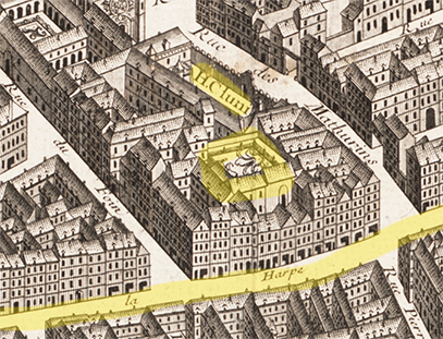
Detail from the Plan de Turgot, drawn by Louis Bretez and engraved by Claude Lucas, 1739. Source gallica.bnf.fr / Bibliothèque nationale de France. BnF- Bibliothèque nationale de France
Going back much further, to the thirteenth century, a Jewish cemetery lay opposite the baths, on the other side of what is now Boulevard Saint-Michel. After Philippe IV expelled the Jews in 1306, the land was gradually built over, and gravestones were reused as steps, paving and building material. In 1849, work at the publisher Louis Hachette’s premises on Rue Pierre-Sarrazin brought around eighty stones and fragments to light. Hachette gave them to the Musée de Cluny, and many were later transferred on loan to the Musée d’art et d’histoire du Judaïsme. What makes them particularly touching is that they preserve individual names. Alongside biblical names such as Isaac and Jacob are women called Florie, Reine, Précieuse and Ivette—small glimpses of the people who lived in this neighbourhood seven centuries ago.
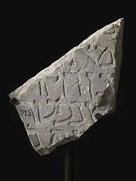
Gravestone fragment from the medieval Jewish cemetery beside Rue de la Harpe, thirteenth century. Paris Musées / Musée Carnavalet – Histoire de Paris. CC0.
This one was discovered during the building of the Cluny Métro station in 1923.
Just a little farther uphill, on the right as we follow the vanished street southwards, stood the medieval church of Saint-Côme-et-Saint-Damien. Its site is at today’s junction of Boulevard Saint-Michel and Rue de l’École-de-Médecine, and its origins go back to around 1212. By the sixteenth century, the surgeons’ confraternity were meeting here on the first Monday of each month—a practice required by royal order in 1544— to give free consultations to poor patients, with apprentices attending to learn.[^17]
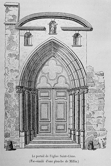
Portal of the church of Saint-Côme, illustration after Millin, reproduced in Topographie historique du vieux Paris, 1887. BIU Santé, Université Paris Cité.
Medicine has a long history in this corner of Paris: the former Saint-Côme anatomy theatre, built in 1691–1694, still stands at 5 Rue de l’École-de-Médecine.[^18]
The former Saint-Côme anatomy theatre
© Alannah Moore, Paris Footprints 2026
The church had a less dignified final chapter. Closed during the Revolution and sold, it became a carpentry workshop before being demolished in 1836 to extend Rue Racine. So that particular disappearance is not one we can blame on Baron Haussmann. [^19]
Here on the Turgot map we can clearly see Saint-Côme and the anatomy college nearby.
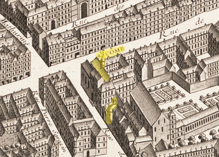
Detail from the Plan de Turgot, drawn by Louis Bretez and engraved by Claude Lucas, 1739. Source gallica.bnf.fr / Bibliothèque nationale de France. BnF- Bibliothèque nationale de France
Opposite Saint-Côme was the old no. 51 Rue de la Harpe, which has a much sadder story. At the end of the eighteenth century it was the home of Jean-Marie Roland de La Platière, the former minister of the interior, and his wife Jeanne-Marie, usually known as Manon. Both had enthusiastically supported the Revolution, and Manon had played an active political role through her writing, advice and gatherings held at their home. But as their Girondin allies lost the struggle for power, the Rolands became targets themselves.[^20]
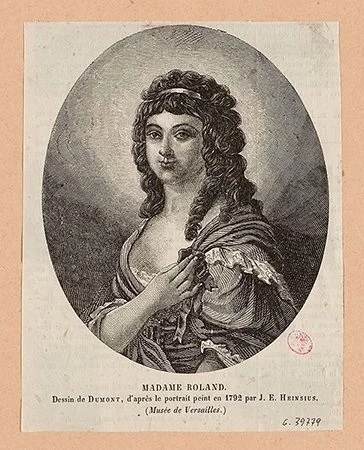
Madame Roland. Engraving by Louis-Paul-Pierre Dumont, after Heinsius, nineteenth century. Paris Musées / Musée Carnavalet – Histoire de Paris. CC0.
On 31 May 1793, officers came to arrest her husband. Manon went to the Convention, the revolutionary parliament, to appeal for help. Her husband evaded arrest by slipping out of the back door via the landlord’s apartment and later escaped Paris, helped by friends. Manon returned home, but was arrested herself in the small hours of the following morning. She wrote her Memoirs in prison and was guillotined on 8 November. Her husband, still in hiding, killed himself shortly afterwards. Their daughter Eudora, who had just turned twelve, was left in the care of family friends.[^21]. And what happened to her is, again, a whole different story.
I haven’t found a photograph showing the vanished stretch of Rue de la Harpe before its demolition. This illustration does show the works in progress in 1857, with carts, rubble and buildings laid bare.[^22]
Jules Férat, Demolition and levelling works on Rue de la Harpe for the construction of Boulevard de Sébastopol (Left Bank), published in L’Illustration, 16 May 1857. Paris Musées / Musée Carnavalet – Histoire de Paris. CC0.
One last detail brings the old street to life: it was a departure and arrival point for coach and carrier services heading to western France. These messageries transported both passengers and goods. The 1692 Livre commode des adresses de Paris—a sort of city handbook—states that you could board departures for Rennes, Nantes, Vannes and other Breton towns from La Rose Rouge on the Rue de la Harpe (clearly an inn or a shop sign) on Thursdays and Saturdays. For Angers, Saumur, Bourgueil and other destinations in the Loire Valley, you went to L’Image Saint-Eustache, “at the bottom of the street”, on Wednesdays or Saturdays.[^23]
Before leaving the old street, I want to share one more image I came across. In 1860, clearances around the old Place Saint-Michel—at the uphill end of Rue de la Harpe, near today’s Place Émile-Rostand—exposed stretches of Philippe Auguste’s medieval wall and its towers. The gate itself had gone in 1684, but these remnants had survived, long concealed among later buildings. Jules Gaildrau’s engraving captures their reappearance before they too were demolished. For a brief moment, the nineteenth-century clearances had brought an even older Paris back into view.
Jules Gaildrau, Old walls of Paris uncovered during the demolition of Place Saint-Michel, published in L’Illustration, 28 July 1860. Brown University Library, via Wikimedia Commons. Public domain.
Next time you walk along Rue de la Harpe, notice the uneven building lines, the old doorways and the abrupt ending at Boulevard Saint-Germain. Pause to admire the eighteenth-century buildings on the odd-numbered side and look for the “NJ” initials at no. 45. Then imagine carrying on uphill, past the baths, the church and the colleges, all the way to the medieval gate. When you walk along the southern stretch of modern-day Boulevard Saint-Michel, you’re following a street whose missing length now lies beneath your feet.
Rue de la Harpe and Boulevard Saint-Michel are perfect illustrations of two different ways in which Paris was made: one developed through centuries of gradual growth; the other was imposed across the existing city in a single generation. I find it fascinating that Boulevard Saint-Michel, one of the best-known boulevards in Paris, is a relatively recent arrival. Its construction, together with that of Boulevard Saint-Germain, utterly changed the layout of this part of Paris, sweeping away streets, buildings and landmarks that had shaped the neighbourhood for centuries.
Footnotes and References
[^1]: Félix and Louis Lazare, Dictionnaire administratif et historique des rues de Paris et de ses monuments (1844), entry “Harpe (rue de la)”; Laurent Gloaguen, “Rue de la Harpe, c. 1866”, Vergue (18 December 2016), reproducing the expanded 1855 Lazare entry and describing the shortening of this major Left Bank street. Lazare, 1844; Vergue.
[^2]: Lazare and Lazare, Dictionnaire (1844), entry “Harpe (rue de la)”, on the gate’s construction around 1200, its successive names and demolition in 1684. For its position relative to present-day streets, see “Porte d’Enfer”, section “Situation”. The gate belonged to the early-thirteenth-century Left Bank section of Philippe Auguste’s enclosure.
[^3]: Gloaguen gives a reduction from 635 metres to 220 metres, a loss of 415 metres. This means roughly two-thirds of the former street disappeared. Vergue, “Rue de la Harpe, c. 1866”.
[^4]: Ville de Paris, Présentation du 6e arrondissement, discussion of Boulevard Saint-Michel: the northern section was opened in the 1850s and the boulevard extended in 1859. Its present name dates from the prefectural order of 26 February 1867; it was previously Boulevard de Sébastopol, Rive Gauche. City of Paris historical presentation; street nomenclature and decrees.
[^5]: Lazare and Lazare, Dictionnaire (1844), entry “Harpe (rue de la)”, records the street in 1247 and attributes the name to a sign. The more specific King David tradition appears in Édouard Fournier, Histoire des enseignes de Paris; the historical nomenclature also contains harp-related Latin names for different sections. Lazare; Fournier, digitised volume. These traditions should not be taken as documentary proof of the original sign’s appearance.
[^6]: Marie-Madeleine Compère, Les collèges français, XVIe–XVIIIe siècles. Répertoire 3 : Paris (INRP, 2002), entries “Dainville”, pp. 151–155, “Bayeux”, pp. 88–93, and “Sées”. Séez was demolished for Rue des Écoles in 1854; Narbonne and Bayeux were lost to the boulevard works. For Narbonne, see the historical drawing and demolition record. For Harcourt’s replacement, see the Île-de-France regional inventory, “Les lycées franciliens : la formation d’un modèle architectural”. “Gone” refers to the colleges as standing establishments: Bayeux’s portal survives in the Musée de Cluny collection, and a door from Harcourt survives inside Saint-Louis (Ministry of Culture, PA00088647).
[^7]: For medieval student conflict, including the 1229 confrontation and ensuing suspension of teaching, and the international, Latin-speaking university community, see Cours de civilisation française de la Sorbonne, “Medieval Universities of Paris: How the Sorbonne Shaped European Higher Education”. The Bibliothèque interuniversitaire de la Sorbonne holds the act suspending courses in 1229. These references concern medieval Paris generally, not a documented disturbance in Rue de la Harpe itself.
[^8]: Compère, “Bayeux”, p. 88. The source states that the college owned a shop on Rue de la Harpe, rented to an innkeeper in the late seventeenth century, then to a rôtisseur. It says allusions in the deliberations suggest that the food seller supplied bursars below market price. The source does not assign an exact date to the later rôtisseur tenancy, so it does not securely date that particular arrangement to the late seventeenth century.
[^9]: Musée Carnavalet, “Rue de la Harpe, vue prise de la rue de la Huchette”, inventory PH767, dated 1865–1868; Gloaguen, Vergue, 21 December 2016, dates the view to approximately 1866. This is a documentary reference for the date and viewpoint, not an image credit.
[^10]: Gloaguen, “Rue de la Harpe, c. 1866”, Vergue, 21 December 2016, identifies nos. 1 and 3 as standing on the projected alignment and no. 5 as the first projecting house in Marville’s photograph.
[^11]: For the successive prescribed widths and property-by-property setbacks, see Lazare and Lazare, Dictionnaire (1844), “Harpe (rue de la)”. A projecting building line is evidence of an earlier alignment; by itself it does not establish an exact construction date or prove that a building has never been rebuilt.
[^12]: Musée Carnavalet, “Rue de La Harpe, vue prise du boulevard Saint-Germain”, inventory PH766, 1865–1868. The historical shop identification rests on the lettering visible in the photograph; the comparison with the present shop is my observation.
[^13]: Gloaguen, “Rue de la Harpe, c. 1866”, Vergue, 18 December 2016, identifies no. 55 at the Boulevard Saint-Germain corner as the projected line and explains that the intended setback of the adjoining odd-numbered houses was never carried out. The text’s connection between this uncompleted widening and the surviving houses is an interpretation of that evidence.
[^14]: Ministry of Culture, Mérimée notice PA00088450: 1730, master builder Charles Bernard; façade and roof on Rue de la Harpe and staircase with wrought-iron balustrade listed on 28 December 1979. For the building’s appearance around 1917, see Carnavalet, inventory PH25004.
[^15]: Paris Promeneurs, “La maison Juliennet”, citing Alexandre Gady, La Montagne Sainte-Geneviève et le Quartier Latin (Hoëbeke, 1998): construction around 1741, architect François Debias-Aubry, patron Nicolas Juliennet, initials NJ, sculpted heads and sale in 1751. The precise year “1741” in the article is therefore approximate in this source. For Baillon’s office and the identity of the queen, see Musées Occitanie, “Jean Baptiste Albert Baillon”.
[^16]: For the baths’ Roman function and frigidarium, see Musée de Cluny, “Les thermes de Cluny”, room information sheet. For later uses and access through a house on Rue de la Harpe until 1819, see Le palais des thermes et l’hôtel de Cluny, notes (1836) and the archaeological account “Les thermes de Cluny. Un imposant vestige de Lutèce au cœur du Quartier Latin”, Dossiers d’archéologie, no. 371 (2015). Carnavalet also preserves the scene Le Tonnelier du palais des thermes de Julien, vers 1800, P180. The suggestion that the street “must have veered significantly” is my inference, not established by these sources.
[^17]: Pierre Julien, “La Confrérie des Saints Côme et Damien à Luzarches”, Revue d’histoire de la pharmacie, 61, no. 218 (1973), pp. 505–518, especially p. 505, for the Paris church’s location and origins around 1212. For first-Monday free consultations and apprentices’ attendance, see “Ambroise Paré, le plus fameux des barbiers-chirurgiens”, La Revue du Praticien.
[^18]: Pierre-Louis Laget, “L’amphithéâtre d’anatomie de la communauté des chirurgiens de Paris sis rue des Cordeliers”, Bulletin monumental, 156, no. 4 (1998). Study of the surviving anatomy theatre, constructed in 1691–1694.
[^19]: Julien, “La Confrérie des Saints Côme et Damien à Luzarches”, p. 505: the church was closed during the Revolution, converted into a carpentry workshop and demolished in 1836 for Rue Racine. See also Lazare and Lazare, Dictionnaire (1844), entry on Rue de l’École-de-Médecine.
[^20]: For Manon Roland’s political activity and persecution as a Girondin, see Ville de Paris, “Chez Madame Roland, femme politique”, Parcours Révolution, and Siân Reynolds, Marriage and Revolution: Monsieur and Madame Roland (Oxford University Press, 2012). The address in the article is the old no. 51, not the present-day building carrying that number; see the address discussion in “Rue de la Harpe” and Claude Perroud’s edition of the 1793 letters in the following note.
[^21]: Manon Roland, Lettres de Madame Roland de 1780 à 1793, edited by Claude Perroud (Imprimerie nationale, 1900–1902), “Année 1793”, introductory chronology, section III: failed arrest of Jean-Marie on 31 May, Manon’s arrest during the night of 31 May–1 June, execution on 8 November and her husband’s suicide during the night of 10–11 November. Perroud directs readers to Mémoires, vol. I, pp. 9–23, for the attempted arrest, escape and Manon’s appeal to the Convention.
[^22]: Musée Carnavalet, Démolitions, travaux de terrassement et de nivellement dans la rue de la Harpe, pour le percement du boulevard de Sébastopol (rive gauche), Jules Férat, inventory 2021.0.1302, wood engraving published in L’Illustration, 16 May 1857.
[^23]: Nicolas de Blégny, writing as Abraham du Pradel, Le Livre commode des adresses de Paris pour 1692, vol. II, edition annotated by Édouard Fournier (Paris: Paul Daffis, 1878), section “Messageries”, pp. 166–170. The original entries give La Rose rouge, Breton destinations and Thursday/Saturday departures (p. 167), and L’Image Saint-Eustache, Loire destinations and Wednesday/Saturday departures (p. 170).